
Weather Front Lesson
Cold front activity
Before starting this exercise it will be helpful to read about weather fronts first. You can click on "What Are Weather Fronts?" from the menu above. It will also be helpful to learn about the meteograms on this website. They are a little different in appearance from those presented in here, but they work basically the same way. Again you can click on "Mesonet Meteograms" from the menu above. Once you have learned what fronts and meteograms are and have read about detecting frontal passage (or FROPA) on a meteogram, you are ready to start this exercise.
Part I: Detecting a cold front
In this first part of the exercise you will look at a set of 3 dates and pick the day and time when a cold front came through. You will use the Mobile (USA Campus) station. Navigate to the "Mesonet Meteograms" page and select Mobile (USA Campus). Then examine the following 3 dates:
1 Feb 2011
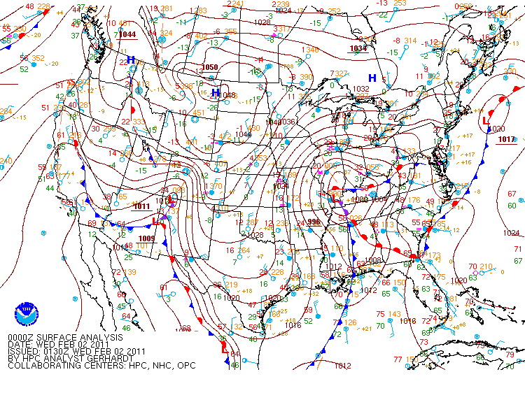
2 Feb 2011
3 Feb 2011
Remember, you must select the next day to see a specific date because the meteogram goes back 24 hours in time. The correct date will be shown on the meteogram itself. Be sure to set the hour and minute sliders to zero. Which of the 3 days experienced a frontal passage and at what time did the front come through? Remember to focus on the sharpest drop in temperature and dew-point after the minimum in pressure has been reached. You can use a ruler or pencil to read off the time of FROPA.
Click here to see the answer
Click here to see a weather map coinciding with that time period
Here is another set of dates. Again, identify the day and time of FROPA.
25 Nov 2010
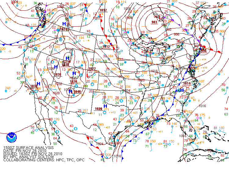
26 Nov 2010
27 Nov 2010
Click here to see the answer
Click here to see a weather map coinciding with that time period
Part II: Studying a cold front case
A very notable cold front passed through the south Alabama region on 26 November 2010. Using the "Mesonet Meteograms" page, complete the table below. Remember, you must select the next day in the meteogram Date box to see a specific date because the meteogram goes back 24 hours in time from the selected date. The correct date will be shown on the meteogram itself. Be sure to set the hour and minute sliders to zero. For each station shown in the table, record the time of frontal passage (to the nearest 15 minutes) and the maximum temperature recorded within the hour preceding frontal passage. Focus on the sharpest drop in temperature and dew-point after the pressure minimum has been reached. You can use a ruler or pencil to read the time of FROPA off the meteogram.
| Station | Time of FROPA (CST) | Maximum temperature before FROPA (°F) |
|---|---|---|
| Leakesville | 5:15 am | 70 |
| Mt. Vernon | 6:15 am | 69 |
| Atmore | 7:30 am | 68.5 |
| Jay | 8:15 am | 67 |
| Dixie | 8:30 am | 70 |
| Florala | 10:30 am | 70 |
| Geneva | 12:00 am | 75 |
| Ashford | 1:00 pm | 77 |
Questions:
- Using the "What is a mesonet?" page, what stands out about the location of the stations in the table?
- What direction (north, east, south, or west) was the front moving in as it progressed through our area?
- Why were the temperatures at Geneva and Ashford much warmer than at the other stations?
Click here to see the answers
Answers:
- The station are located progressively further east as you move down the list.
- The front was moving to the east. It reached the western most station (Leakesville) first and then moved steadily to the east, passing each station. This is what most cold fronts do. They approach our area from the west because they are embedded in larger scale westerly flow which is common in our area during late fall and winter. Weather maps showing the progression of the front can be found here.
- The cold front passed those stations after the sun was high enough in the sky by the time it reached those stations. This caused some warming at those stations.