
The north-central Gulf of Mexico coastal region´s climate and weather is influenced to a large extent by the warm waters of the Gulf of Mexico. This geographical location provides a mild subtropical climate (Koppen Cfa) characterized by hot, humid summers and mild, rainy winters. The summers are consistently warm, but temperatures are seldom as high as they are at inland stations. Normally, in summer, the day begins in the low 70s and the temperature rises rapidly before noon to the high 80s or low 90s, when it is checked by the onset of the sea breeze. On the rare occasions when northerly winds prevail throughout the day, temperatures may reach the high 90s or rise slightly above 100 degrees. Winter weather is usually mild except for occasional invasions of cold air that last about three days. January is the coldest month in the year. Unusual winters may produce readings that require extensive protective measures as some citrus fruit is grown in the area and outdoor nurseries are numerous.
The yearly rainfall is among the highest in the United States. It is fairly evenly distributed throughout the year with a slight maximum at the height of the summer thunderstorm season and a slight minimum during the late fall. Rainfall is usually of the shower type and long periods of continuous rain are rare. Extreme windstorms and damaging weather-related events are common in the Southeast United States. In the cooler months, mid-latitude cyclones and their attendant fronts commonly traverse the area, acting as focal points for heavy rainfall and severe local storms. Frontal thunderstorms may occur in any month of the year. There may be a thunderstorm every other day in July and August. These summer storms are usually not too violent and seldom produce hail. Due to its proximity to the subtropical waters of the Gulf of Mexico, the Gulf Coast area is vulnerable to hurricanes. In the late summer and fall, recurving tropical cyclones may interact with frontal systems over the area to produce widespread and persistent heavy rainfall and penetration of strong winds well inland. Tornadoes are infrequent at the coast but do occur, however the frequency at which they occur in inland portions of Gulf Coast states is much greater.
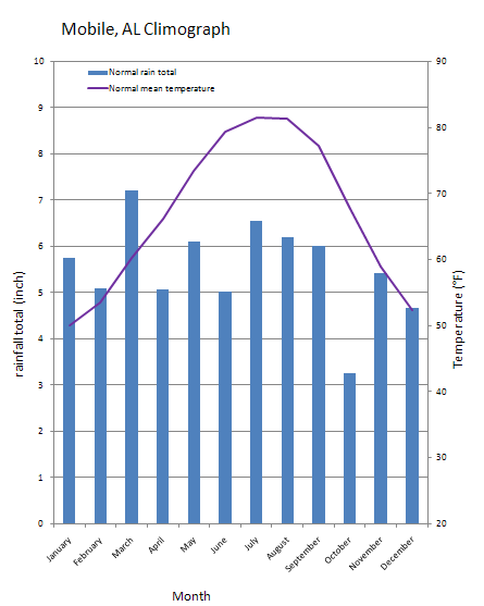
The image at left is known as a climograph. This image shows long-term average monthly rainfall totals and mean temperatures based on data from 1971 through 2000 available from NOAA´s National Climatic data Center (NCDC). We have prepared 12 regional climographs for yoWe have prepared 12 regional climographs for youu. These stations are from a region that coincides with the area of the USA Mesonet. Using the tool found here you can create an annual climograph for any Mesonet station of your choice which you can then compare to a long-term average from a station nearby.